
Objective partnered with the organisation’s data and design teams to create a bespoke defence online research tool. The result provides defence analysts, policymakers, and researchers with an in-depth view of international infrastructure, investment, and connectivity projects.
Context
A global authority in defence, security, and international relations research wanted to make its extensive data and insights more accessible to analysts, governments, and academic audiences.
Having previously collaborated with the organisation on defence analytics systems – including a relational web database for global military data and an economic forecasting tool for defence budgets – Objective was trusted to build a new digital platform capable of handling complex, multilingual research datasets.
The Challenge
The main challenge was to consolidate years of data into an accessible interface that defence analysts and policymakers could use to explore investment patterns, regional trends, and project outcomes across hundreds of countries.
The tool needed to manage large-scale geolocation data, visualise time-based trends, and deliver a user experience suitable for both technical experts and general audiences.
The Solution
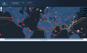
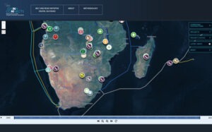
Objective developed a defence-focused online research platform with a secure CMS database, interactive dashboard, and map-based data engineering.
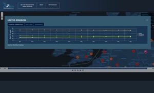
Users can explore the evolution of infrastructure and connectivity projects over the past two decades, filter projects by investor or region, and correlate findings with key indicators such as digital penetration, sovereign debt, and governance metrics.
The platform covers over 170 countries and multiple territories, with biannual dataset updates intended. Built around a transparent research methodology, it integrates officially recognised and comparable projects — providing a complete picture of global defence and connectivity initiatives.
The Results & Benefits
This defence online research tool has become a valuable digital resource for professionals across defence, academia, government, and industry. It enables users to visualise complex geopolitical and economic relationships through an intuitive, interactive format.
Key features include:
- Comprehensive Filtering: Search projects by funding source, contractor, or region.
- Interactive Timeline: View the progression of projects over time, from planning to completion.
- Detailed Insights: Access summaries including project status, outcomes, and verified data sources.
Project Outcome
Enabled data-driven insights across global defence projects, simplified complex datasets with interactive visualisation tools, accelerated analysis with real-time filtering and mapping